- Year 1891
- 20-08-1891
- 21-08-1891
- 22-08-1891
- Scandinavia tour year 1891 (Denmark, Sweden, Norway, Denmark)
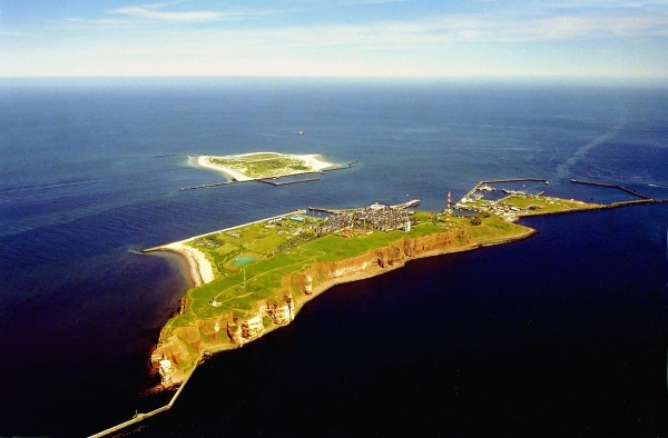
- Sylt Island – Helgoland Island – Hamburg
Helgoland (German: Heligoland, Heligolandic Frisian deät Lun “the Land”) is a small German archipelago in the North Sea. Formerly Danish and British possessions, the islands (population 1,127) are located in the Heligoland Bight (part of the German Bight) in the southeastern corner of the North Sea. These islands are the only German islands not in the immediate vicinity of the mainland and are approximately three hours’ sailing time from Cuxhaven at the mouth of the River Elbe. In addition to German, the local population, who are ethnic Frisians, speak the Heligolandic dialect of the North Frisian language called Halunder. Heligoland was formerly called Heyligeland, or “holy land”, possibly due to the island’s long association with the god Forseti.
Geography
Heligoland is located 46 kilometres (29 mi) off the German coastline and consists of two islands: the populated triangular 1 km2 (0.4 sq mi) main island (Hauptinsel) to the west, and the Düne (“dune”, Heligolandic: de Halem) to the east. The former is what the place name “Heligoland” is normally used to refer to. Düne is somewhat smaller at 0.7 km2 (0.27 sq mi), lower, and surrounded by sand beaches. It is not permanently inhabited, but is today the location of Heligoland’s airstrip.
The main island is commonly divided into the Unterland (“Lower Land”, Heligolandic: deät Deelerlun) at sea level (to the right on the photograph, where the harbour is located), the Oberland (“Upper Land”, Heligolandic: deät Boperlun) consisting of the plateau visible in the photographs and the Mittelland (“Middle Land”) between them on one side of the island. The Mittelland came into being in 1947 as a result of explosions detonated by the British Royal Navy.
The main island also features small beaches in the north and the south and drops to the sea 50 metres (160 ft) high in the north, west and southwest. In the latter, the ground continues to drop underwater to a depth of 56 metres (184 ft) below sea level. Northwest of the island proper Heligoland’s famous landmark is found: the Lange Anna (“Long Anna” or “Tall Anna”) is a free standing rock column (or stack), 47 metres (154 ft) high.
The two islands were connected until 1720, when the natural connection was destroyed by a storm flood. The highest point is on the main island, reaching 61 metres (200 ft) above sea level. Although culturally closer to North Frisia in the German district of Nordfriesland, the two islands are part of the district of Pinneberg in the state of Schleswig-Holstein. The main island has a good harbour and is frequented mostly by sailing yachts.
Climate
The climate of Heligoland is typical of an offshore climate, being almost free of pollen and thus ideal for people with pollen allergies. Since there is no land mass in the vicinity, temperatures rarely drop below ?5 °C (23 °F) even in the winter. At times, winter temperatures can be higher than in Hamburg by up to 10 °C (18 °F) because cold winds from Russia are weakened. While spring tends to be comparatively cool, autumn on Heligoland is often longer and warmer than on the mainland, and statistically, the climate is generally sunnier. The coldest temperature ever recorded on Heligoland was ?11.2 °C (12 °F) in February 1956,while the highest was 28.7 °C (84 °F) in July 1994.
Owing to the mild climate, figs have reportedly been grown on the island as early as 1911, and a 2005 article mentioned Japanese bananas, figs, agaves, palm trees and other exotic plants that had been planted on Heligoland and were thriving. There still is an old mulberry tree in the Upper Town.
Geology
The island of Heligoland is a geological oddity; the presence of the main island’s characteristic red sedimentary rock in the middle of the German Bight is unusual. It is the only such formation of cliffs along the continental coast of the North Sea. The formation itself, called the Bunter sandstone or Buntsandstein, is from the early Triassic geologic age. It is older than the white chalk that underlies the island Düne, the same rock that forms the white cliffs of Dover in England and cliffs of Danish and German islands in the Baltic Sea. In fact, a small chalk rock close to Heligoland, called witt Kliff (white cliff), is known to have existed within sight of the island to the west until the early 18th century, when storm floods finally eroded it to below sea level.
Heligoland’s rock is significantly harder than the postglacial sediments and sands forming the islands and coastlines to the east of the island. This is why the core of the island, which a thousand years ago was still surrounded by a large, low-lying marshland and sand dunes separated from coast in the east only by narrow channels, has remained to this day, although the onset of the North Sea has long eroded away all of its surroundings. A small piece of Heligoland’s sand dunes remains—the sand isle just across the harbour called Düne (Dune). A referendum in June 2011 dismissed a proposal to reconnect the main island to the Düne islet with a landfill.
19th Century
On 11 September 1807, during the Napoleonic Wars, HMS Carrier brought to the Admiralty the despatches from Admiral Thomas McNamara Russell announcing Heligoland’s capitulation to the British. Heligoland became a centre of smuggling and espionage against Napoleon. Denmark then formally ceded Heligoland to George III of the United Kingdom by the Treaty of Kiel (14 January 1814). Thousands of Germans came to Britain and joined the King’s German Legion via Heligoland.
The British annexation of Heligoland was ratified by the Treaty of Paris signed on 30 May 1814, as part of a number of territorial reallocations following on the abdication of Napoleon as Emperor of the French. The prime reason at the time for Britain’s retention of a small and seemingly worthless acquisition was to restrict any future French naval aggression against the Scandinavian or German states. In the event no effort was made during the period of British administration to make use of the islands for naval purposes. This was partially for financial reasons but mainly because the Royal Navy considered Heligoland to be too exposed as a forward base.
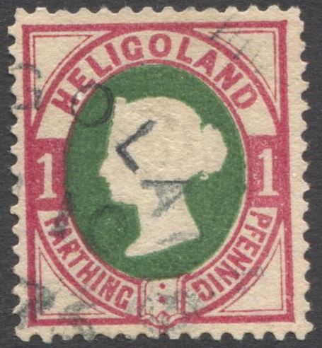
Helgoland Island stamp.
In 1826, Heligoland became a seaside spa and soon it turned into a popular tourist resort for the Hanoverian upper-class. The island also attracted artists and writers, especially from Germany and even Austria who enjoyed the freedom of the benignly ruled (British) island, including Heinrich Heine and August Heinrich Hoffmann von Fallersleben. It was a refuge for revolutionaries of the 1830s and the 1848 German revolution.
Britain gave up the islands to Germany in 1890 in the Heligoland-Zanzibar Treaty. The newly unified Germany was concerned about a foreign power’s controlling land from which it could command the western entrance to the militarily-important Kiel Canal, then under construction, as well as other naval installations in the area, and traded for it. A “grandfathering”/optant approach prevented the Heligolanders (as they were named in the British measures) from forfeiting advantages because of this imposed change of status.
Heligoland has an important place in the history of the study of ornithology, and especially the understanding of migration. The book Heligoland, an Ornithological Observatory by Heinrich Gätke, published in German in 1890 and in English in 1895, described an astonishing array of migrant birds on the island and was a major influence on the future studies of bird migration, in Britain in particular.